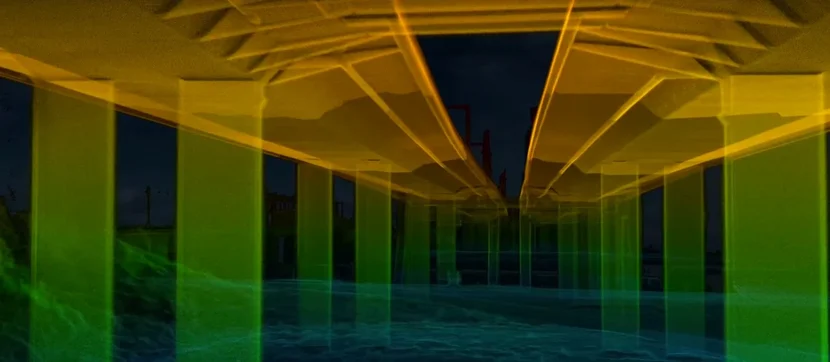
Back in October 2023, Flyability and our partner Droprise decided to put the Elios 3 and its innovative LiDAR payload to the test. Our mission? To conduct a road bridge survey in Belgium—a busy stretch of motorway that sees heavy traffic every single day. Safety The Surveying Payload allowed us to access the entire 600-meter length of the bridge without putting anyone at risk. By carefully flying the drone in a way that avoided distracting or disrupting traffic, we ensured a safe and efficient operation. These areas, which are usually hard to reach, were now accessible without the need for risky work-at-height operations. Efficiency The Elios 3 managed to complete the entire survey of the bridge in just four flights, all within a single day. This approach minimized the time required for inspections, allowing us to quickly determine whether any maintenance work was necessary without needing to divert traffic. The efficiency of this method was a game-changer for us. Accuracy The Surveying Payload delivered impressive results, with over 90% of the collected data accurate to within one centimeter. This level of precision is crucial for detailed inspections and ensures that the data we collect is highly reliable. The ability to achieve such high accuracy with minimal disruption was a significant achievement. Business Development We chose not to fly directly over the bridge deck to avoid any distractions to the ongoing traffic. Despite this, we were still able to create a complete 3D model of the bridge using data collected from below and beside the structure. This demonstrates the versatility and adaptability of the Elios 3 and its Surveying Payload. Flyability introduced the Elios 3 Surveying Payload with the goal of offering a LiDAR payload for our flagship drone that could handle more complex tasks. Designed with advanced features, the payload enhances data coverage, mapping efficiency, and overall accuracy. Together with our partner Droprise, we set out to demonstrate these capabilities in a real-world scenario: a road bridge survey in Belgium. Professional drone operators and surveyors now have two options when choosing the LiDAR payload for their Elios 3 drone, each tailored to different needs. The standard configuration, featuring the Rev 6.2 LiDAR, is ideal for projects requiring a broad overview with moderate accuracy. On the other hand, the Surveying Payload, equipped with the Rev 7 LiDAR, excels in environments where precision is paramount. It’s perfect for challenging spaces like underground mines, wastewater systems, and bridges—projects demanding centimeter-level accuracy. The Surveying Payload uses the Rev 7 LiDAR to bridge data gaps in difficult environments. Partnered with processing software FARO Connect, it delivers exceptional performance. During testing, over 90% of the collected data was accurate within 2 cm, with the device scanning 1.3 million points per second and covering distances up to 100 meters. Processing with FARO Connect automatically merges point clouds and reduces noise, thanks to settings specifically designed for Flyability drones. In October 2023, Droprise and Flyability took the Surveying Payload and Elios 3 to a unique site to demonstrate its capabilities in a practical setting. Droprise, our Belgian partner and reseller since 2019, specializes in drone inspection and surveying services for construction and infrastructure projects. They’ve witnessed the evolution of the Elios drone series, from Elios 1 to 2 and now the flagship Elios 3. However, pitching the Surveying Payload to potential clients proved challenging because the local market values tangible ROI before adoption. To address this, Droprise needed a demonstration proving the payload’s value in a realistic environment. The bridge survey was completed with the Elios 3 Surveying Payload. With permission granted to inspect critical elements of a bridge on a busy motorway, the team from Droprise and Flyability focused on collecting data beneath and alongside the structure. Flying directly over the bridge was not permitted due to traffic concerns, so the goal was to create a 3D model using data gathered from these angles. A bridge survey with the Elios 3 showcased its ability to deliver high-quality data in both indoor and outdoor environments. Unlike conventional drones, the Elios 3 operates without GPS, relying instead on a visual camera (VIO) and LiDAR stabilization for navigation. Its compatibility with Remote ID makes it suitable for markets like the US, where regulatory compliance is crucial. The lack of GPS dependency allows the Elios 3 to navigate tight spaces, such as under bridges, where other drones might lose connection. This project highlighted the drone’s capabilities with clear results and expanded functionalities. Given the busy nature of the motorway, safety was a priority. The team ensured that the drone was flown at specific angles relative to the road, avoiding direct overhead flights. This bridge, built in 2014, spans water frequently used by shipping vessels. Although structurally sound, accessing the underside for inspection would require elaborate scaffolding, making it an ideal site to demonstrate the Elios 3’s advantages. The drone made it possible to access the bridge safely and efficiently, setting a precedent for future bridge inspections without unnecessary complications. The amazing LiDAR results are clearly visible in this video. The 600-meter-long bridge was surveyed from multiple angles in just four flights. The pilot ensured that no flights crossed the active highway while still gathering comprehensive data from close proximity to the underside. With the Rev 7 LiDAR capturing 1.5 million points per second, the resulting point cloud was incredibly dense. The team observed from the FlyAware live model that they were capturing a complete view of the bridge. Afterward, the data was processed with FARO Connect to merge multiple flights and reconstruct the bridge in 3D. The point cloud generated from this flight provided an impressively clear and detailed view of the bridge structure. Despite collecting data from limited angles, the final model offered a comprehensive representation of the bridge. This outcome showcases the Surveying Payload’s potential in delivering high-quality data for major infrastructure projects. Droprise can now use this footage to demonstrate the data quality to potential clients, particularly those managing large-scale infrastructure projects across Belgium. In the future, they plan to conduct a follow-up flight, georeferencing the data to leverage the Surveying Payload’s enhanced accuracy and FARO Connect’s automated georeferencing capabilities. This will streamline the digitization process, enabling the creation of a centimeter-accurate, localized model of the bridge. Zinc Fume Extraction, Electric Capture Zinc Smoke Acid Mist,dust collector,baghouse dust collector Xinbai Plating(jiangsu) Intelligent Technology Co.,Ltd , https://www.hotgalvanizing.comTesting the Elios 3 Surveying Payload: Mapping a 600-Meter Bridge Without Disrupting Traffic
Understanding the Elios 3 LiDAR Payloads
 The new Elios 3 LiDAR payload takes mapping capabilities to the next level.
Mapping a Road Bridge Without Stopping Traffic
Methodology for Drone Mapping a Road Bridge
Results of Road Bridge Survey with a Drone